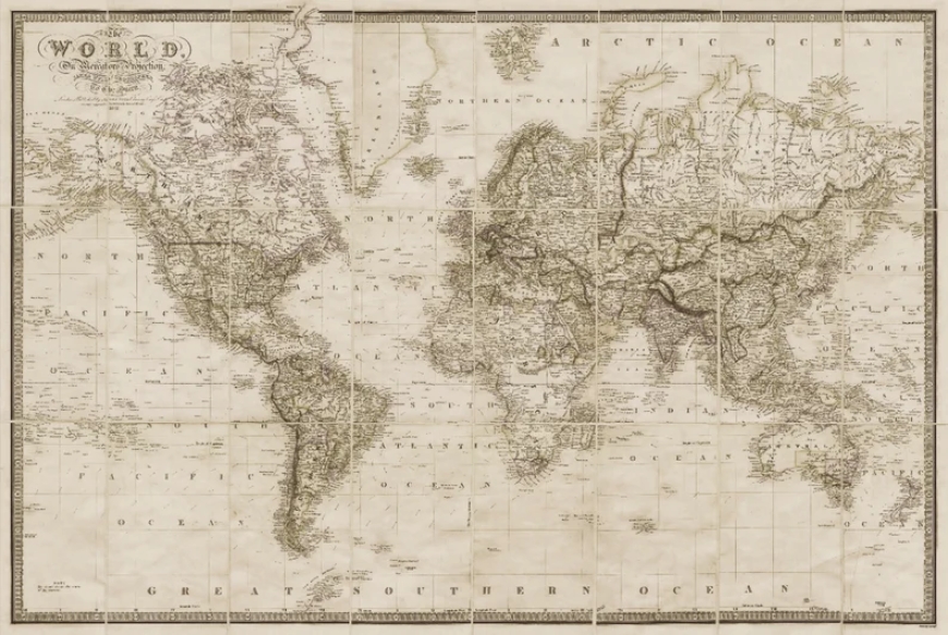
In an era where GPS technology guides our every move, the intricate artistry and historical significance of antique city maps offer a compelling contrast. These beautifully crafted pieces serve not only as navigational tools of the past but also as windows into the urban development, culture, and ambitions of civilizations gone by. Antique city maps are treasured not merely for their cartographic information but also for their aesthetic appeal and the stories they tell.
The Birth of Urban Mapping in Antiquity
The practice of mapping cities can be traced back to ancient civilizations such as Babylon, Rome, and Greece. One of the earliest known city maps is the clay tablet of Nippur from ancient Mesopotamia, dating back to around 1500 BCE. As empires expanded and cities flourished, the need to chart these growing urban spaces became essential. These early maps were less about precise scale and more about conceptual layouts, often highlighting religious or political centers to reflect cultural priorities.
Medieval City Maps: Symbolism Over Precision
During the medieval period, maps were predominantly religious or symbolic rather than geographic. Many medieval maps featured Jerusalem at the center, emphasizing spiritual significance over spatial accuracy. The famed “T and O” maps are prime examples, dividing the world into three parts—Asia, Europe, and Africa—with Jerusalem often occupying the central position. When cities were depicted, they were shown with exaggerated importance and stylized layouts, prioritizing iconography over orientation.
The Renaissance: A Turning Point in Urban Cartography
The Renaissance marked a transformative era in mapmaking, especially for city plans. As the thirst for knowledge, exploration, and scientific discovery grew, so did the precision and detail in cartography. Artists like Leonardo da Vinci and cartographers such as Jacopo de’ Barbari began producing more accurate and geometrically grounded city maps. De’ Barbari’s bird’s-eye view of Venice from 1500 is an exquisite example, combining artistry with a surprisingly accurate depiction of urban geography.
Golden Age of City Mapping in the 16th and 17th Centuries
The 16th and 17th centuries witnessed a golden age of cartography, propelled by European exploration, imperial ambitions, and the rise of printing technology. Cities like London, Paris, Rome, and Amsterdam were captured in stunning detail. Maps from this period were not just practical guides but grand representations of power and prestige. They adorned the homes of aristocrats and were used to impress visiting dignitaries.
Many of these maps featured elaborate borders, coats of arms, illustrations of people and animals, and artistic flourishes. The inclusion of perspective—often bird’s-eye views—allowed viewers to appreciate the urban layout as if soaring above the rooftops. These works straddled the line between informative documents and decorative art.
Baroque Influence and the Flourish of Decorative Maps
By the 18th century, the influence of the Baroque era was visible in urban maps. Embellishments became more intricate, with lavish cartouches, allegorical figures, and mythological themes. These maps reflected not only the physical structure of cities but also the artistic tastes of the time. Cities were not just plotted; they were celebrated.
These antique maps served multiple purposes: military planning, civic administration, and propaganda. They illustrated the extent of territorial control, displayed the grandeur of urban planning, and even guided architecture and city expansions. The maps of this period are especially popular among collectors today due to their aesthetic sophistication.
Antique City Maps as Works of Art
More than utilitarian tools, antique city maps are appreciated today as masterful works of art. The techniques used—engraving on copper plates, hand-coloring, and calligraphy—required immense skill and craftsmanship. Each map was a labor of love, taking weeks or even months to complete. Collectors and historians prize them for their artistic merit and the insight they offer into artistic conventions of different eras.
What makes these maps stand out is their dual purpose. They satisfy both the analytical mind and the artistic eye. The fine lines, the symmetry, and the harmonious layout all contribute to an enduring visual appeal. Whether hung on a wall or kept in a portfolio, these maps continue to evoke wonder and admiration.
Collecting Antique City Maps: A Journey Through Time
The allure of collecting antique city maps lies in their blend of history, beauty, and rarity. Collectors often focus on specific cities, historical periods, or styles of mapping. Some seek maps that show the early development of metropolises like New York, Paris, or Istanbul. Others are drawn to thematic or decorative elements, such as elaborate borders or artistic renderings.
Provenance, condition, age, and cartographer are essential factors in determining value. Maps by renowned figures like Blaeu, Ortelius, and Homann are highly prized. Even lesser-known works can be valuable if they capture a pivotal moment in urban evolution or offer an unusual perspective.
Auctions, antique dealers, and specialized map fairs are common venues for acquiring antique maps. With the rise of digital marketplaces, reputable online stores now make it easier than ever for enthusiasts to start or expand their collections.
City Maps as Historical Documentation
Each antique city map is a documentary record, capturing the layout and character of a city at a particular moment in time. They can reveal everything from the location of defensive walls and trade routes to the emergence of new districts or the aftermath of urban disasters like fires or floods.
Maps from different time periods can be compared to trace the evolution of city planning and infrastructure. For instance, historical maps of London show its transformation from a Roman outpost to a medieval stronghold, through the devastation of the Great Fire, to its emergence as a global metropolis.
Urban historians, architects, and geographers rely heavily on these maps for research. They offer insights into migration patterns, industrial development, and socio-political dynamics within cities. In this way, antique city maps serve as valuable scholarly resources beyond their visual appeal.
Preservation and Restoration of Antique Maps
Given their age and fragility, preserving antique city maps is an art in itself. Many are printed on materials like vellum or rag paper, which, while more durable than modern paper, are still susceptible to damage from light, humidity, and handling.
Conservation experts often use archival techniques to clean, flatten, and repair maps. Acid-free matting, UV-filtering glass, and controlled environments are essential to prolong their life. Digital archiving has also become increasingly important, allowing wider access while protecting the originals.
Collectors are encouraged to consult with conservation professionals before attempting any restoration, as improper methods can irreversibly damage these historical treasures.
The Modern Revival of Antique Map Aesthetics
Today, the charm of antique city maps is experiencing a revival in both interior design and digital media. Reproductions are used in home décor to evoke a sense of history and sophistication. Interior designers frequently incorporate large-scale map prints in libraries, studies, and living rooms to create a timeless ambiance.
Moreover, digital tools are enabling artists and designers to reinterpret antique styles for modern audiences. Interactive maps, city history apps, and virtual museum exhibits often draw upon antique cartographic aesthetics, blending past and present in captivating ways.
Some publishers and tech firms are even combining historical maps with modern data overlays to tell rich, layered stories of urban transformation. These projects highlight how antique city maps remain relevant in the digital age.
Conclusion: Rediscovering Cities Through Cartographic Treasures
Antique city maps are more than artifacts; they are stories etched in ink and parchment. They invite us to rediscover cities as they were envisioned centuries ago, full of promise, mystery, and grandeur. Whether admired for their artistic splendor, valued as collector’s items, or studied as historical documents, these maps offer a timeless portal into the urban past.
In a world constantly chasing the future, antique city maps remind us of the paths already traveled. They show us that every modern skyline once began as a cartographer’s careful sketch, a dream drawn in meticulous detail. Exploring these old maps is not just about looking back—it’s about seeing how far we’ve come and appreciating the beauty in the journey.