


![How much should I charge for an educational consulting role? I have a PhD, 12 years of experience [closed]](https://cdn.sstatic.net/Sites/workplace/Img/apple-touch-icon@2.png?v=d39b333f5c58)


![Kyoto Hotel Refuses To Check In Israeli Tourist Without ‘War Crimes Declaration’ [Roundup]](https://viewfromthewing.com/wp-content/uploads/2025/04/war-crimes-declaration.jpeg?#)


![New Best Ever Bonus for Capital One Venture Card Available Through Referrals [YMMV]](https://boardingarea.com/wp-content/uploads/2025/04/6cbab7b59a0f3413c2a8f73cf771602a.png?#)


NASA Advances Precision Landing Technology with Field Test at Kennedy
Landing on the Moon is not easy, particularly when a crew or spacecraft must meet exacting requirements. For Artemis missions to the lunar surface, those requirements include an ability to land within an area about as wide as a football field in any lighting condition amid tough terrain. NASA’s official lunar landing requirement is to […]
Landing on the Moon is not easy, particularly when a crew or spacecraft must meet exacting requirements. For Artemis missions to the lunar surface, those requirements include an ability to land within an area about as wide as a football field in any lighting condition amid tough terrain.
NASA’s official lunar landing requirement is to be able to land within 50 meters (164 feet) of the targeted site and developing precision tools and technologies is critically important to mission success.
NASA engineers recently took a major step toward safe and precise landings on the Moon – and eventually Mars and icy worlds – with a successful field test of hazard detection technology at NASA’s Kennedy Space Center Shuttle Landing Facility in Florida.
A joint team from the Aeroscience and Flight Mechanics Division at NASA’s Johnson Space Center’s in Houston and Goddard Space Flight Center in Greenbelt, Maryland, achieved this huge milestone in tests of the Goddard Hazard Detection Lidar from a helicopter at Kennedy in March 2025.

The new lidar system is one of several sensors being developed as part of NASA’s Safe & Precise Landing – Integrated Capabilities Evolution (SPLICE) Program, a Johnson-managed cross-agency initiative under the Space Technology Mission Directorate to develop next-generation landing technologies for planetary exploration. SPLICE is an integrated descent and landing system composed of avionics, sensors, and algorithms that support specialized navigation, guidance, and image processing techniques. SPLICE is designed to enable landing in hard-to-reach and unknown areas that are of potentially high scientific interest.
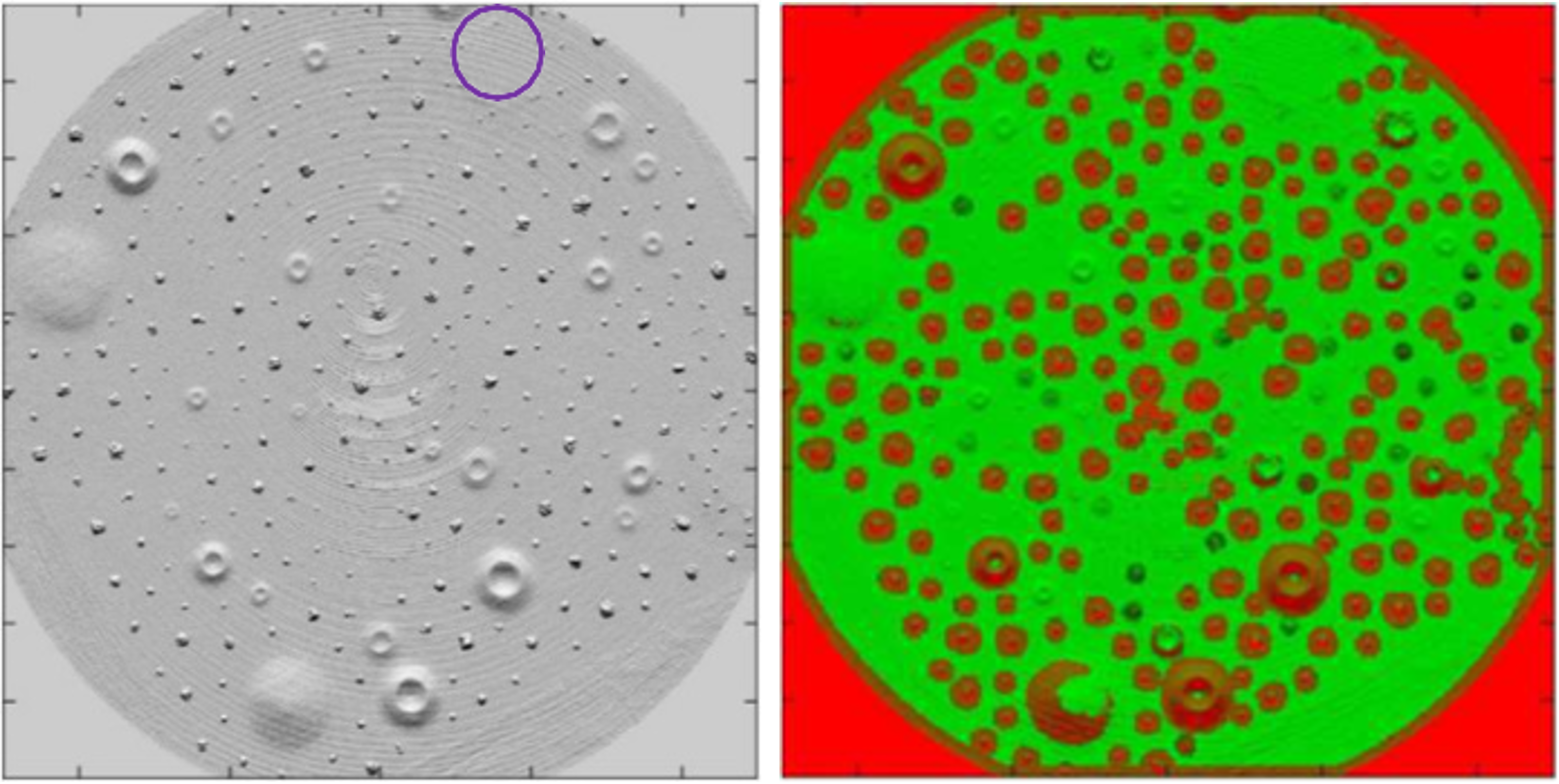
The lidar system, which can map an area equivalent to two football fields in just two seconds, is a crucial program component. In real time and compensating for lander motion, it processes 15 million short pulses of laser light to quickly scan surfaces and create real-time, 3D maps of landing sites to support precision landing and hazard avoidance.
Those maps will be read by the SPLICE Descent and Landing Computer, a high-performance multicore computer processor unit that analyzes all SPLICE sensor data and determines the spacecraft’s velocity, altitude, and terrain hazards. It also computes the hazards and determines a safe landing location. The computer was developed by the Avionics Systems Division at Johnson as a platform to test navigation, guidance, and flight software. It previously flew on Blue Origin’s New Shepard booster rocket.

For the field test at Kennedy, Johnson led test operations and provided avionics and guidance, navigation, and control support. Engineers updated the computer’s firmware and software to support command and data interfacing with the lidar system. Team members from Johnson’s Flight Mechanics branch also designed a simplified motion compensation algorithm and NASA’s Jet Propulsion Laboratory in Southern California contributed a hazard detection algorithm, both of which were added to the lidar software by Goddard. Support from NASA contractors Draper Laboratories and Jacobs Engineering played key roles in the test’s success.
Primary flight test objectives were achieved on the first day of testing, allowing the lidar team time to explore different settings and firmware updates to improve system performance. The data confirmed the sensor’s capability in a challenging, vibration-heavy environment, producing usable maps. Preliminary review of the recorded sensor data shows excellent reconstruction of the hazard field terrain.
Beyond lunar applications, SPLICE technologies are being considered for use on Mars Sample Return, the Europa Lander, Commercial Lunar Payload Services flights, and Gateway. The DLC design is also being evaluated for potential avionics upgrades on Artemis systems.
Additionally, SPLICE is supporting software tests for the Advancement of Geometric Methods for Active Terrain Relative Navigation (ATRN) Center Innovation Fund project, which is also part of Johnson’s Aeroscience and Flight Mechanics Division. The ATRN is working to develop algorithms and software that can use data from any active sensor – one measuring signals that were reflected, refracted, or scattered by a body’s surface or its atmosphere – to accurately map terrain and provide absolute and relative location information. With this type of system in place, spacecraft will not need external lighting sources to find landing sites.
With additional suborbital flight tests planned through 2026, the SPLICE team is laying the groundwork for safer, more autonomous landings on the Moon, Mars, and beyond. As NASA prepares for its next era of exploration, SPLICE will be a key part of the agency’s evolving landing, guidance, and navigation capabilities.