


![New iPhone Factory Goes Live in India, Another Just Days Away [Report]](https://www.iclarified.com/images/news/97165/97165/97165-640.jpg)


5 recommended GIS tiling software that supports SHP files!
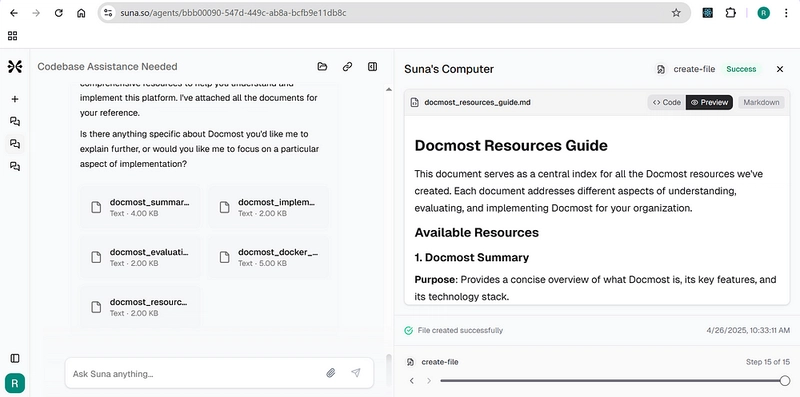
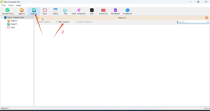
SHP (Shapefile) files are one of the most widely used vector data formats in the field of geographic information systems (GIS). They are indispensable in the field of handling various spatial data such as terrain, buildings, roads, and administrative districts. In particular, in recent years, the need to convert SHP data into map tiles (3DTiles, VectorTiles, etc.) and visualize them on the web has rapidly increased. In this article, we will introduce five excellent software that can directly read SHP files and output them as GIS tiles. A must-read for those who are working on data visualization and business efficiency! QGIS Supported OS: Windows / macOS / Linux Price: Free (open source) Features: A flexible plugin system allows you to display, edit, and even convert SHP files into web tiles. Recommended uses: Urban planning, map learning in educational institutions, and introduction to GIS for beginners. ArcGIS Pro Supported OS: Windows Price: Paid (commercial license) Features: Esri's high-performance GIS platform. Centralized management from SHP file analysis to spatial analysis and web distribution. Recommended uses: Large-scale projects in local governments, public works, and research institutions. Global Mapper Supported OS: Windows Price: Paid (trial version available) Features: Intuitive UI for quick loading and processing of SHP files. Supports high-performance 3D display and point cloud processing. Recommended uses: For on-site use such as surveying, civil engineering, and drone mapping. GISBox Supported OS: Windows Price: Paid (free trial available) Features: 3D GIS slice generation software. Convert SHP files to 3DTiles or VectorTiles with one click. Can also be directly distributed to Cesium, Wings Engine, etc. Recommended uses: Specialized in 3D spatial utilization for architecture, real estate, disaster prevention, smart city development, etc. MapTiler Desktop Supported OS: Windows / macOS Price: Free plan available / Commercial license available Features: Specialized in generating web maps. Easily output base maps and MBTiles from SHP files. Recommended uses: Web developers, front-end GIS construction, lightweight map services. The key to utilizing SHP files is "visualization and distribution" SHP files are a treasure trove of spatial information assets accumulated at many sites. However, to share and utilize them with more people, tile visualization on the web is essential. By introducing tools that can easily convert SHP files into tiles, such as GISBox and MapTiler Desktop, you can significantly improve work efficiency.
SHP (Shapefile) files are one of the most widely used vector data formats in the field of geographic information systems (GIS). They are indispensable in the field of handling various spatial data such as terrain, buildings, roads, and administrative districts. In particular, in recent years, the need to convert SHP data into map tiles (3DTiles, VectorTiles, etc.) and visualize them on the web has rapidly increased.
In this article, we will introduce five excellent software that can directly read SHP files and output them as GIS tiles. A must-read for those who are working on data visualization and business efficiency!
- QGIS
Supported OS: Windows / macOS / Linux
Price: Free (open source)
Features: A flexible plugin system allows you to display, edit, and even convert SHP files into web tiles.
Recommended uses: Urban planning, map learning in educational institutions, and introduction to GIS for beginners.
- ArcGIS Pro Supported OS: Windows
Price: Paid (commercial license)
Features: Esri's high-performance GIS platform. Centralized management from SHP file analysis to spatial analysis and web distribution.
Recommended uses: Large-scale projects in local governments, public works, and research institutions.
- Global Mapper Supported OS: Windows
Price: Paid (trial version available)
Features: Intuitive UI for quick loading and processing of SHP files. Supports high-performance 3D display and point cloud processing.
Recommended uses: For on-site use such as surveying, civil engineering, and drone mapping.
- GISBox Supported OS: Windows
Price: Paid (free trial available)
Features: 3D GIS slice generation software. Convert SHP files to 3DTiles or VectorTiles with one click. Can also be directly distributed to Cesium, Wings Engine, etc.
Recommended uses: Specialized in 3D spatial utilization for architecture, real estate, disaster prevention, smart city development, etc.
- MapTiler Desktop
Supported OS: Windows / macOS
Price: Free plan available / Commercial license available
Features: Specialized in generating web maps. Easily output base maps and MBTiles from SHP files.
Recommended uses: Web developers, front-end GIS construction, lightweight map services.
The key to utilizing SHP files is "visualization and distribution"
SHP files are a treasure trove of spatial information assets accumulated at many sites. However, to share and utilize them with more people, tile visualization on the web is essential. By introducing tools that can easily convert SHP files into tiles, such as GISBox and MapTiler Desktop, you can significantly improve work efficiency.